Sunday, March 16, 2025

Snowstorm for the 19th

 For Wednesday the 19th there will likely be a snowstorm over the Upper Midwest. Confidence is increasing that a swath of 6+ inches of snow will be possible over Iowa, Wisconsin, and lower Minnesota. It is still uncertain where this swath exactly will set up because of the exact path of the system. Within the swath, blizzard conditions or close to that, will be possible on Wednesday. The two models below show the uncertainty of the path and width of the heavy snow. The GFS model showing the system having more moisture and going slightly more north than the Icon model. To further complicate this system, it will likely start as rain at the onset of the precipitation, changing to snow west to east as the system moves more east and the cold air wraps around it. It should be noted that the cold air will only be around 30-34 degrees so a bump up or down would wildly change amounts or who gets snowfall. (images from https://www.tropicaltidbits.com/


Saturday, March 15, 2025

Heavy Snow for Wednesday the 19th

For Wednesday the 19th a heavy snowstorm looks to impact the Upper Midwest. The CMC model shows a swath of very heavy snowfall, although the totals it shows here might be inflated. There will likely be a path of 6-12 inches of snowfall, with the potential for blizzard conditions. The path of heavy snowfall will probably be adjusted north or south depending on the exact track. If you live in Iowa, Wisconsin, or lower Minnesota please keep a eye on this system for Wednesday as this could significantly impact your travels. (image from tropicaltidbits.com)


Severe Weather Outbreak Today

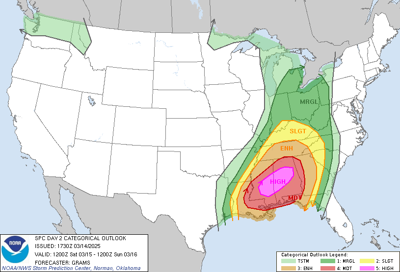
A tornado outbreak is very likely to happen today in Alabama, Mississippi, and the nearby areas. Please have a way to get alerts. Multiple long track, strong tornadoes are likely to happen. Please take any warnings seriously, and take cover for your safety. (Images from the National Weather Service)


Friday, March 14, 2025

Severe Weather threat today and tommorrow

 It is going to be a very impactful day for a lot of states today. All types of severe weather will be possible. In Iowa the main risk will be winds, with hail and tornadoes although the higher tornado risk is staying to the south, but a couple tornadoes can't be ruled out in Iowa.  For the rest of the states, all severe types will be possible with strong tornadoes, damaging winds, and severe hail being possible. If you are in the enhanced or moderate risk, or know someone who is please make sure they have a way to get alerts as this isn't a normal threat. There will likely be multiple tornadoes tonight with a  couple being strong; unfortunately this will mostly be happening during the night, and if you get a alert please take cover for your own safety. (Images from the National Weather service showing the categorical outlook, damaging wind threat, and tornado threat. ) 


For tomorrow a rare high risk has been issued and a Tornado outbreak is likely to happen over the south. If you are in the enhanced risk -especially the moderate or high risk- please have a way to get alerts and please take any warnings seriously. Take cover immediately as this isn't your normal threat, please have a plan in place in case you are caught in warning area tomorrow. (images from the National Weather Service)


Saturday, March 1, 2025

Severe Weather Threat 3/4 and 3/5

 Tuesday will be impactful for the southern states with a severe weather threat. Main threat is damaging wind gusts and strong tornadoes. The area in the 30% (images from the National Weather Service) has the best chance to see this type of weather. Overnight Tuesday the line is expected to weaken, bringing a much lower threat as it moves through Georgia. On Wednesday it is expected to re-strengthen in the morning, putting the East Coast back into a  15% chance for severe weather, but it won't likely get to the same strength as Tuesday. The main threat will be damaging winds, however a couple of tornadoes can't be ruled out. The line on Wednesday should hit the coastal areas in the afternoon, exact timing will have to wait a couple of days to see the speed of the system.


The north side of this system will bring snow for the northern United States on Tuesday and Wednesday. Wisconsin, Minnesota, and northern half of Iowa, will likely see 1-4 inches over most of the area. A curved band of 6+ inches  may form but that area depends on how the system sets up. Over the whole area, it will start as rain, changing to snow as the low pressure moves to the east. 


Sunday, February 23, 2025

Weather for Monday 2/24

 The weather for coastal South Carolina will have high's in the mid to upper 60s, a light isolated shower or two can't be ruled out before noon southwest of Charleston. The midlands will have a high in the lower to mid 60s, with the upstate area being around 60 degrees. 


To our southeast, Florida will see a rainy day on Monday with the rain ending by early Tuesday morning for most of the state, the eastern coast and to the south will still likely see showers through Tuesday afternoon. Accumulations show most of the state seeing 0.5-1 inches of rain, with southern Florida seeing around 1-2 inches of rain. (Image from the National Weather Service) 


Wednesday, February 19, 2025

Weather for Wednesday 2/19


For snowfall today the likely area that sees 8-12 inches of snowfall in North Carolina and Virginia is that small area in pink (model from https://www.tropicaltidbits.com/). Southeast North Carolina has the highest risk of seeing 0.1-0.25 of ice accumulation (ice images
from the National Weather Service) with northeast South Carolina seeing a chance for light ice  accumulations. There is still a chance to see a trace of snow as far south as Columbia. Coastal South Carolina will see rain accumulations of around 0.5 inches with our highs being around the lower 50s at noon and dropping into the upper 30s by 7pm.